About Planimeter GPS Area Measure
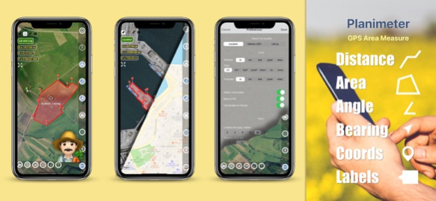
Distance, angle, bearing and area calculation, Metric | Imperial unit, open | save | share KML/CSV, Edit | Fit points, add points with Lat - Lng, GPS TRACKING, Notes Planimeter is a tool to measure distance, area and...
Distance, angle, bearing and area calculation, Metric | Imperial unit, open | save | share KML/CSV, Edit | Fit points, add points with Lat - Lng, GPS TRACKING, Notes
Planimeter is a tool to measure distance, area and perimeter on a map. You can measure manually or by GPS tracking. You can also check the bearing and geo-coordinates of your location and share it. Points can be labeled, saved and shared in KML format.
This measurement app is useful for outdoor activities and can be used as land surveyor by amateurs and professionals in various industries like sport, farming, landscaping, paving and construction, road building and repairing, real estate business, hiking and travel, fencing, lot building and planning, solar panel installation (roof area estimation), object mapping, lawn design, and many other where land area and distance / length calculations, land survey or maps are involved.
If you have any question about Planimeter and its functionality, please check How To Use Quick Guide:
http://ios.vistechprojects.com/Planimeter_iOS_QuickGuide.pdf
Video Demo:
http://youtu.be/unjYbPCIYM0
http://youtu.be/QQMilHVD5e8
Features:
Accurate distance and area calculation
Metric and Imperial units (m, km, feet, yards, miles, ha, acres)
Angle between lines
Bearings To and From the point
Forth and Back navigation through points by touch on Info Panel
GPS coordinates of a point
GPS accuracy settings (if GPS available)
Manage previously saved projects: open, save, share KML files
KML files created by Planimeter can be imported to GEarth and GMaps to view on a desktop
Send data by email: picture, coordinates as text message, KML file
Save KML or TXT in local storage
Map/Satellite View
Zoom and Edit points
Current location search
Text (address) search
Delete selected/last/all points
Zoom to Fit-in and center points on a screen - quick points search
Add points by touch
Add current location as a point
Show location with Latitude and Longitude coordinates
Add points by Geo-coordinates: Lat and Lng
Option to center last point added
Option to show/hide lines
Preferences: location accuracy, tracking time interval, delete points confirmation, sound option for tracking
Separate units settings for distance, area, perimeter
Target Mode for accurate pin placement
Show current coordinates in Target Mode
Stylus Draw Mode
Full-screen option
GPS TRACKING
Manual pin placement in GPS Tracking
The app has been successfully used in different areas:
- outdoor activities: sports, golf (distance between two points or holes), bike tours, trail planning, travelling, quick path measure
- garden and yard: landscape planning, grass cutting, lawn care and mowing, fencing, grass seeding.
- agriculture, poultry and farming: harvesting, fertilizing, crops (corn, wheat, maize, beet, etc.) planning and estimation, field area measure, paddocks and area fencing for cows, horses, chickens, rabbits, etc.
- solar energy: area estimation for solar panels, flat roof area estimation
- construction: land survey, road sealing, parking lot repairing
- forestry: objects and tree mapping, damage area estimation, measure land area
- other: ponds size and are measure; pole lines planning; movement tracking; get exact GPS coordinates of way-points; fence calculation; geocaching.
Note: Continued use of GPS running in the background can dramatically decrease battery life.
If you like the app and find it useful please support us with your feedback and comment.
Feel free to contact
[email protected] with any questions, comments or bug reports.
Feb 13, 2024
Version 2.1.14
- settings to hide notes in the Note mode for better pins placement
- improvements in PDF report
- stability improvements
Previous Versions
Here you can find the changelog of Planimeter GPS Area Measure since it was posted on our website on 2016-09-23 19:56:09.
The latest version is 2.1.14 and it was updated on 2024-04-22 21:08:13. See below the changes in each version.
Planimeter GPS Area Measure version 2.1.14
Updated At: 2024-02-13
Changes: Feb 13, 2024
Version 2.1.14
- settings to hide notes in the Note mode for better pins placement
- improvements in PDF report
- stability improvements
Planimeter GPS Area Measure version 2.1.13
Updated At: 2024-02-02
Changes: Feb 2, 2024
Version 2.1.13
- settings to hide notes in the Note mode for better pins placement
- improvements in PDF report
- stability improvements
Planimeter GPS Area Measure version 2.1.12
Updated At: 2023-02-23
Changes: Feb 23, 2023
Version 2.1.12
- settings to hide notes in the Note mode for better pins placement
- improvements in PDF report
- stability improvements
Planimeter GPS Area Measure version 2.1.11
Updated At: 2022-06-07
Changes: Jun 7, 2022 Version 2.1.11
- fixes to PDF report
- stability improvements
Planimeter GPS Area Measure version 2.1.9
Updated At: 2022-05-02
Changes: May 2, 2022 Version 2.1.9
fixes and stability improvements
Planimeter GPS Area Measure version 2.1.8
Updated At: 2021-10-19
Changes: Oct 19, 2021 Version 2.1.8
Improved sharing options:
project name, description, and date can be saved and shared via KML
fixes and stability improvements
Planimeter GPS Area Measure version 2.1.7
Updated At: 2021-10-02
Changes: Oct 2, 2021 Version 2.1.7
Improved sharing options:
project name, description, and date can be saved and shared via KML
fixes and stability improvements
Planimeter GPS Area Measure version 2.1.6
Updated At: 2021-09-20
Changes: Sep 20, 2021 Version 2.1.6
Improved sharing options:
- project name, description, and date can be saved and shared via KML
fixes and stability improvements
Planimeter GPS Area Measure version 2.1.4
Updated At: 2021-08-13
Changes: Aug 13, 2021 Version 2.1.4
project name, description and date can be saved to KML and PDF
improved sharing options KML, CSV, PDF
points number in the report
screenshot improved
bug fixes
Planimeter GPS Area Measure version 2.1.3
Updated At: 2021-05-09
Changes: 9 May 2021 Version 2.1.3
improved sharing options KML, CSV, PDF
points number in the report
screenshot improved
bug fixes